
Steve Freihon/Related-Oxford
New York, New York
Global experience.
Regional perspective.
Local impact.
New York, New York
Australia

London, United Kingdom

Diriyah, Riyadh, Saudi Arabia

 Thornton Tomasetti
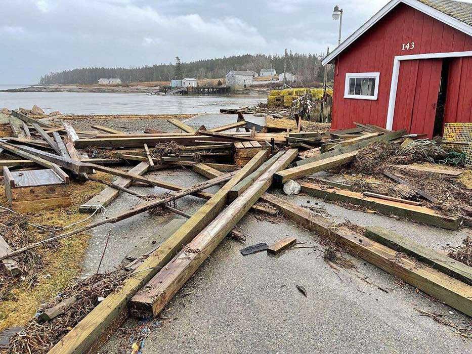
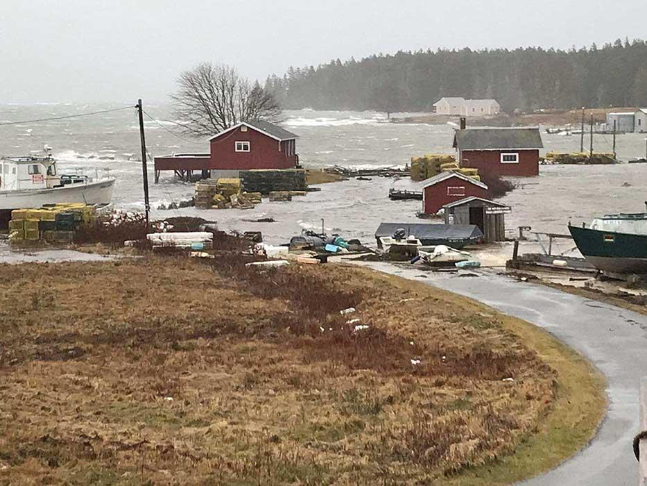
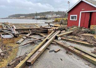
On January 10, 2024, a combination of seasonal high tides and heavy rain systems hammered the Maine coastline with record flood waters and left our coastal communities with significant repair, rebuild and resilience work. Record-breaking water levels were observed in Maine (NOAA):
A major aspect of this record storm event was the unlucky coincidence of the storm occurring during the new moon, as new and full moons drive higher tides. Tides were at a seasonal high with predictions exceeding 10 feet (blue line) due to the January 11 new moon, and the storm surge added an additional 3 to 5 feet to the water levels (red line) due to a combination of strong onshore winds and nearly 2.5-3.5 inches of precipitation.
 Predicted and preliminary observed water levels for the NOAA monitoring station in Portland Harbor. Flood severity annotations by Thornton Tomasetti. Courtesy NOAA.
Strong winds were the primary driver of the storm surge experienced. In the graph below you can see winds recorded by the same monitoring station from January 9 to 11. Onshore wind (seen as east to west arrows in this graph) is typically the cause of storm surge during these types of events, with stormwater runoff being secondary depending on extent of land development in the region and proximity to inland drainage systems, like rivers or sewer and stormwater networks.
 Observed wind direction and velocity by the NOAA monitoring station in Portland Harbor. Courtesy NOAA.
To better understand the potential impact of the storm event on the built environment within the coastal communities, our team collected coastal data and conducted high-level geographic information system (GIS) analyses. For our analyses, we gathered elevation and storm data from NOAA and estimated building footprints from Microsoft. When considering the entirety of Maine’s coast, we found just over 6,000 structures that fell within reach of the observed storm surge elevations provisionally provided by the Portland monitoring station highlighted in the figures above.
 Our state-wide estimates of buildings vulnerable to the January 10 storm surge.
This value is conservative, as some locations recorded a storm surge up to 3 feet higher. Below are some selected area maps showing land within the storm surge’s reach and the buildings that may have been affected.
 Goose Rocks Beach and Goosefare Bay in Kennebunkport.
 Old Orchard Beach, Nonesuch River delta, and Prouts Neck.
 South Harpswell down to Newagen, including Popham, Phippsburg, Bath. Also included are the outlets of the Kennebec, Sasanoa, and Sheepscot Rivers.
This work is a rough estimate, as recorded storm surge height varies by location and is affected by the shape of bays, shoreline, wind exposure and underwater topography (bathymetry). Nevertheless, it highlights the extent of Maine's coastal vulnerability and can help determine which structures are at risk and what course future flooding may take.
Extreme weather has long fostered self-reliance and resilience within Maine communities. The recent storms have highlighted this strength and provide an opportunity to rebuild even stronger. By leveraging cutting-edge technology, engaging in comprehensive urban or coastal planning, and fostering strong community partnerships, we can meet future storms head-on. This proactive approach is not just about recovery, it’s about ensuring that Maine's coastline remains a beacon of resilience.
Major storm events can have a significant impact on our built environment. Thornton Tomasetti has the experience and expertise to offer clients in need of repairing or rebuilding their homes, as well as strengthening the resilience of their homes before another major storm event.
Evaluate damage
If you were affected by the storm and need to better understand your situation, our Forensics team are industry leaders in property evaluation. We assist attorneys, property managers, building owners, contractors/manufacturers and design professionals with a wide range of engineering and architectural forensic services. As design professionals, we evaluate for standard of care; as forensic specialists, we seek root cause; as problem solvers, we seek resolution. Our deliverables typically include a report, expert testimony, a set of calculations/drawings and computer models and simulations.
Rebuild safe
Need to repair and rebuild after the storm? With decades of experience in restoration, structural evaluation and building envelope renewal, our Restoration & Renewal team is uniquely equipped to navigate the intricate process of inspecting, repairing and upgrading buildings to not only restore their former integrity but also to reposition them for future resilience and sustainability. Leveraging cutting-edge technologies like drone inspections and advanced analytical modeling, we ensure that each project benefits from thorough investigation, precision in design and cost-effective solutions tailored to the unique needs of each client. Our commitment to integrating structural robustness with aesthetic preservation makes us the partner of choice for renewing the vitality of properties impacted by natural disasters.
Plan for a resilient future
If recent storms are kicking off resilience and sustainability planning initiatives in your community or organization, our Resilience team is available to help. Our approach to resilience emphasizes not just recovery but the strategic enhancement of buildings and infrastructure to withstand and adapt to future flood risks. By combining our expertise in structural modeling, hazard simulation and floodproofing design with comprehensive cost-benefit analyses and sustainability assessments, we offer solutions that encompass the full spectrum of resilience planning—from individual asset optimization to community-wide evaluations. Our use of approachable web interfaces and easy-to-understand formats for complex data ensures that decision-making is collaborative, informed and aligned with both immediate recovery goals and long-term resilience objectives. We strive to empower communities and stakeholders to make proactive choices that prioritize safety, efficiency and environmental stewardship in the face of climatic challenges.
Reach out for local assistance
Our Portland office is a 45+ person strong team with expertise in structural design, forensics, restoration and renewal, sustainability and resilience. We are located at 14 York St. in Portland, Maine and can be reached at +1.207.245.6060.
Helpful Resources